


One of the ways in which we can tackle the climate crisis is through tree planting. However, this may not be as simple as it seems, it is certainly not a quick solution, and it is definitely not a substitute for reducing CO2 and other greenhouse gas emissions.
Why are trees and woodlands so important in tackling the climate crisis? Because they store carbon within their structures, or biomass as it is technically referred to. However, it is worth pointing out that equal or even greater amounts of carbon are stored in woodland soils, so it is not just the tree it is what is below the tree that is also important. while woodland soils store substantial amounts of carbon, many grassland soils, particularly those of wet grasslands, and other wetland habitats store vastly more carbon than woodland soils1. Which is good to know, because although Eastbourne does not have a lot of tree cover, especially as woodland, it has large areas of wet grassland in the form of grazing marsh in the Eastbourne Park and Eastbourne levels areas.
East Sussex is one of the most wooded counties in England, with 17% woodland cover compared to the national average of 12.5%. But if you live in Eastbourne, that might seem a stretch to imagine given that Eastbourne and much of the surrounding landscape are not very wooded. That is because the bulk of woodland in the county is within the High Weald, north of Horam, which is in fact the most woodland landscape in the whole of England.
So, does this mean lots of tree planting should be happening in and around Eastbourne? Well, this is actually quite a complex question. Eastbourne has a completely different underlying geology to the High Weald, which has led to a different historical land use, and that in turn has led to the development of very different, but no less important habitats, which is why the landscape around Eastbourne and the Downs at this Eastern end are characteristically different from the low and high Weald of Sussex. Take the chalk grassland on Eastbourne’s doorstep on the Downs. This is an internationally rare habitat, with 80% of the original extent of chalk grassland lost since WWII. Much of the loss in the last 80 years has been to arable conversion on the dip slopes and spreading secondary woodland on the scarp slopes. Secondary woodland is tree and shrub cover that has naturally regenerated because of extensification – the opposite of agricultural intensification – the land is no longer actively managed.
The South Downs National Park Authority in conjunction with Sussex Nature Partnership have produced an ArcGIS map which helps to sense check potential sites across both East and West Sussex, and the full extent of the South Downs National Park for woodland creation. This map draws on national and local data and is the best woodland opportunity mapping tool we have because it has been developed specifically to be used locally. It removes areas not suitable for woodland creation that are often other important habitats, it then weighs both positive and negative factors of the remaining areas across the counties to give one of three scores depending on how sensitive (suitable) the area is for tree planting. The one down side to this excellent tool is that is cannot be used to ascertain suitability for urban tree planting, as urban areas are screened out.
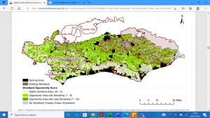
Image source: Mapping Woodland Opportunity in Sussex and the South Downs National Park Technical report, 2022
The map can be found by clicking on the link below. There is a storymap element which explains how the maps work, but if you scroll to the bottom there is an interactive map, which is zoomable:
Sussex and South Downs Woodland Opportunity Mapping (arcgis.com)
This mapping work suggests there is not a great deal of opportunity for woodland creation around Eastbourne. But that is OK, because Eastbourne has other naturally occurring habitats that are just as important if not more important in the fight against climate change. And anyway, the rest of Sussex, and in particular the High Weald AONB holds a place for us with its woodland cover, the same way that the Downs holds chalk grassland for the rest of Sussex. It is a reminder that looking after and restoring all habitats for biodiversity and for us is important, including for future generations, regardless of where those habitats are found.
1 R Gregg, J. L. Elias, I Alonso, I.E. Crosher and P Muto and M.D. Morecroft (2021) Carbon storage and sequestration by habitat: a review of the evidence (second edition) Natural England Research Report NERR094. Natural England, York
Eastbourne is known as seaside town, and the eastern entry point to the South Downs National Park. On one side Eastbourne has the chalk grasslands of the Downs, one of the most species diverse habitats in England. And, on the other side, the wetlands of the Eastbourne and Pevensey levels. Wetlands being globally the most valuable habitats for the services they provide to us – known as ecosystem services.
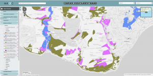
There is probably far more variety of wildlife habitats than you realised in and around Eastbourne, including: good quality semi-improved grassland, chalk grassland, lowland meadows, lowland heathland, coastal and floodplain grassland, traditional orchards, ancient semi-natural woodland, lowland fens, reedbeds, deciduous woodland, and marine cliffs and slopes. Many important habitats are already mapped, especially those referred to as ‘priority’ habitats. These are considered to be the most threatened habitats, and often requiring appropriate management to restore and enhance them. An easy way to get to grips with the types of habitats in and surrounding Eastbourne, is to look on at the publicly available habitat mapping data provided by Defra (department for environment, food and rural affairs) MAGIC (defra.gov.uk) As an ecologist, the first thing I always do when asked about a particular site is to check these maps and find out, which if any priority habitats are at a particular site.
The map below shows many, but not all, of the priority habitats in and around Eastbourne. Each colour is a different habitat type. For example, the blue is grazing marsh – and that is why it is found around the wetlands of Eastbourne levels and Cuckmere Haven area. The Khaki colour is chalk (calcareous) grassland, naturally this is found on the chalk downland to the west of Eastbourne.
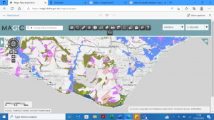
It is worth noting that, there are many important sites that are not on ‘priority’ habitat maps, therefore it is best to treat this data as indicative only, but it certainly gives a good overview. The map also does not indicate the condition of the habitat. Some sites may be thriving habitats, whilst other sites may be in desperate need of appropriate management to restore them back to a good condition.
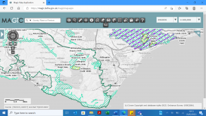
Priority habitats are different however from statutory protection. There can often be some overlap, but many many priority habitat sites have no legal protection. In and around Eastbourne, there are a couple of national nature reserves – Lullington heath, and the Pevensey levels, and a number of Sites of Special Scientific Interest (SSSI) surrounding Eastbourne. SSSI sites have the highest level of national protection, and generally best represent our national heritage either in flora and fauna or geology. This includes the chalk grassland at Willingdon Down found on the Downs behind Willingdon village, and the chalk cliffs which start at the Meads end of the town. Some of the SSSIs are in good condition, whilst others are sadly in a declining in condition, and need urgent appropriate management to help restore them back to the highly valuable habitat they are. This unfortunately includes much of the chalk grassland on the Downs directly above Meads. Whilst the Pevensey levels are generally regarded to be recovering back to good condition.
Statutory sites are also mapped and publicly available from Defra Magic Map Application (defra.gov.uk), and the maps can be used very quickly to assess whether a site has any protection and often what condition the site it is in. The map below shows a variety of conservation designations, from the turquoise stripes of SSSI sites, to the lime green national nature reserves. Of course, every site that should be protected isn’t, and if you compare this map to the one above, you will immediately see quite the discrepancy in priority habitat sites and actual protected sites. But this does not mean these sites are any less valuable for the wildlife that lives there.
If you have the time, I encourage anyone interested to take a look at these maps if not already familiar with them. They are a great resource that are used by professional ecologists and conservationists all the time, and luckily happen to be available to all.
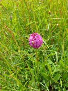
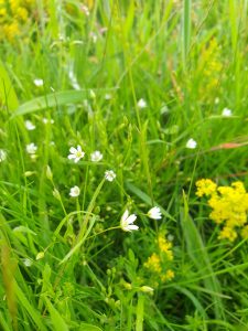
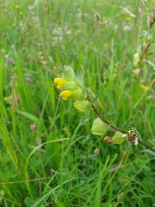
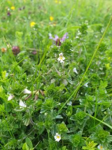
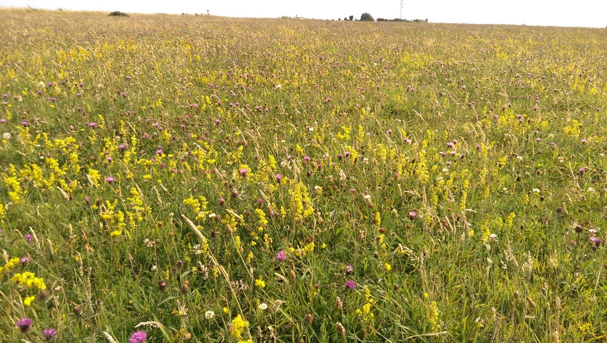
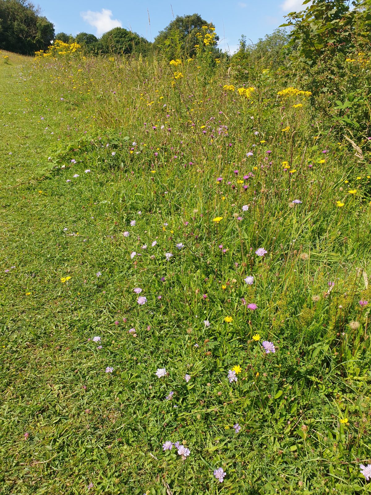
One of the things I love about living in Eastbourne is access straight up onto the South Downs. I enjoy walking on the Downs, taking in the views, especially those that look out to sea, but one of the most enjoyable aspects for me is the chalk grassland. Chalk grasslands are found in northwest Europe, and are some of the most species rich habitats we have, in fact they have even been called the European equivalent to tropical rainforests because they are so species rich. They are particularly rich in plants with up to 45 different species in one square metre on the best sites. You can find many species of orchids, wild thyme and other herbs, tiny eye-brights, milkworts, and fairy flax, bold knap-weeds, and fine grasses as well as the County flower the blue and spikey round-headed rampion. They are also known for their invertebrates, with numerous species beetle, butterfly, moth and grasshopper found exclusively on chalk grasslands.
You would be forgiven for thinking that as we live at the foot of the South Downs – a chalk ridge that runs all the way to Winchester in Hampshire – and that for the most part in the open landscape of the eastern end of the Downs, that chalk grassland is the dominant habitat. Unfortunately like many other habitats in England our abysmal lost of biodiversity has reduced the amount of chalk grassland across the South Downs to just 4 % of its original cover. But before digging into why we have so little left, lets get into what exactly chalk grasslands are.
Chalk grasslands are often referred to as calcareous grasslands. This is a fancier way of saying something is rich in calcium carbonate. In this case it is the chalk bedrock under the soil. However, this is really important as it affects the pH of the soil. That scale of acid to alkaline. And because the bedrock of the South Downs is chalk, the soils here are alkaline. It is worth pointing out that another feature of these soils is that they are generally shallow and very nutrient poor. Sometimes the plants that grow on places like the South Downs are referred to as calcicoles. A calcicole is a botanical word which simply means a chalk loving plant. So, the chalk grasslands on the South Downs are a suit of plants adapted to the alkaline soils which overlay the chalk bedrock, many of which are restricted to growing only in places where chalk or limestone underlay the soil. And despite what may sound contrary, these plants thrive on the thin nutrient poor soils, indeed it is these very conditions that make chalk grasslands so species rich because it stimulates competition between species.
But why is there so little of it, and what is growing on the South Downs if it’s not chalk grassland? There used to be far more chalk grassland on the Downs than there is now and that is due to former land use. Some form of management is required to maintain chalk grasslands. Livestock grazing, on the higher and steeper slopes, especially with sheep is the traditional use of the South Downs. Sheep grazing has been active on much of the Downs since before the Roman times, but was dominant from the medieval period onwards until World War II. The soils on the Downs are shallow and nutrient poor, and often dry because rainwater percolates away quickly through chalk. Conditions that meant that until more recently this land was unsuitable for arable (crop) production, which was confined to the foot of the Downs, although some of the south facing more gentle slopes have been ploughed since the 1700’s. Post-World War II saw the advancement of technology in agriculture through machinery, biocides, fertilizers and resistant crop strains which lead to land that had previously been considered unsuitable for crop production being ploughed up on the South Downs. This greatly affected the way the South Downs were farmed; with only the steepest slopes left unploughed.
The reality is that most of it has been lost. What remains of good quality chalk grassland on the South Downs make up less than 30% of the calcareous grassland in the whole of the southeast of England- other areas include the Surrey Hills and the Kent Downs. Most areas of chalk grassland are confined almost exclusively to highly fragmented patches on the steep north facing slopes called the scarp slope. This becomes really evident if you ever look at the location of protected sites known as Sites of Special Scientific Interest (SSSI’s) across the eastern half of the Downs. They are predominately found on the northern facing slopes. Fragmentation, or the breaking up of large areas of chalk grassland into smaller isolated patches leads to the rapid loss of calcicole plant species from remaining chalk grassland, and associated invertebrates. The good news was that the steeper slopes provided an environment more resistant to change for chalk grasslands, because the soil can be especially thin on these slopes, which in turn favours the calcicole species. However, farming practices are continuing to change, a new problem has arisen as the steeper slopes are abandoned from livestock grazing or indeed any management at all, which has led to the encroachment of scrub and ‘secondary’ woodland. This smothers the grassland and has meant the gradual loss of calcareous grassland on even these steeper north facing slopes as well.
Restoration of chalk grassland often involves the removal of scrub, trees and shrubs and the reintroduction of grazing to maintain its characteristic short grass. If an area can’t be grazed then it can be cut, although the cuttings need to be removed, this is because as cuttings rot down, they return nutrients to the soil and this allows plant species that we wouldn’t normally see gain a foothold into these plant communities, such as nettles. The little calcicoles cannot compete with the likes of quick growing and tall nettles and soon disappear.
Eastbourne is no exception in having lost some of the steep scarp slope to secondary woodland, which more recently has been devastated by ash die-back disease. However, we are also fortunate in Eastbourne as we do still have some really good south facing chalk grassland particularly between Holywell and Cow Gap.
Fortunately chalk grassland is now designated a ‘priority habitat’. This means it is a habitat that has been identified as threatened with loss and requiring conservation action, something that the South Downs National Park is working hard on. There is another important grassland on the chalk slopes around Eastbourne, known as good quality ‘semi-improved grassland’. Good quality semi-improved grassland is the grassland best placed for restoration to chalk grassland, as it contains many of the calcicole species. But what sets it apart from chalk grassland is that it is likely to have been victim to agricultural ‘improvement’ at some point, or other poor management from which it is now recovering from.
If you want to see exactly where chalk and semi-improved grasslands can be found in and around Eastbourne, it is worth first looking at Defra’s Magic Map Application (defra.gov.uk), an open resource that maps all of England’s designated protected sites and areas as well as priority habitats. Below is a snapshot to illustrate all of the priority grasslands found in and around Eastbourne.
I couldn’t write this blog without talking about carbon, because this is the Eastbourne EcoAction website right? Well chalk grassland (and indeed all other species rich grasslands) are a huge source of carbon stores in their soils. In fact, carbon stores in grassland soils are, in some cases are as good as the stores in woodland soils. However, disturbance of the soil, such as ploughing or digging up releases that stored carbon back into the atmosphere and it can take a long-time to restore what has been lost. We also now know that the more species diverse grasslands hold more carbon that species poor grasslands – another great reason to love chalk grasslands, and see them being restored.There are four priority grassland habitats: calcareous grassland (khaki), coastal and floodplain grazing marsh (blue), lowland meadow (lime), and good quality semi-improved grasslands (purple). The map shows how lucky we are to have so much south facing chalk grassland, a rarity indeed. Likewise, we can see how much of the scarp slope facing Eastbourne is good quality semi-improved grassland, ideal for restoration to chalk grassland.
So, although much has been lost, chalk grassland is recognised as one of the most biodiverse habitats we have in this country, and here in Eastbourne have it on our doorstep – our own rainforest in miniature! Restoration projects help enhance and restore it to its former glory and that in turn supports a host of other species, many of which are also in decline that are dependant on it. So next time you are out on the Downs, I encourage you to try and find some of the places the chalk and semi-improved grassland exists, take or download a plant I.D. guide and see what you can find.
Author: Sarah Brotherton is an ecologist who lives in Eastbourne, currently working for the High Weald Area of Outstanding Natural Beauty.


