


Pevensey Bay is a low-lying coastal community in East Sussex, next-door to the large resort town of Eastbourne. The shingle bank along Pevensey Bay’s seafront provides protection from the strong storm surges that often come its way, especially in winter. But the village also experiences flooding inland, as several drainage channels run through it, helping to drain the large water catchment area known as the Pevensey Levels, a freshwater wetland renowned for its wildlife. Because the village is more or less at the level of the high-water mark, the water in the drainage channels can sometimes only be released out to sea when the ebb tide falls below the level of the water in those channels, which can be very full in periods of intense rainfall, periods which will become ever more frequent and intense as anthropogenic climate change accelerates. This can lead to the channels overflowing their banks at times.

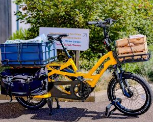
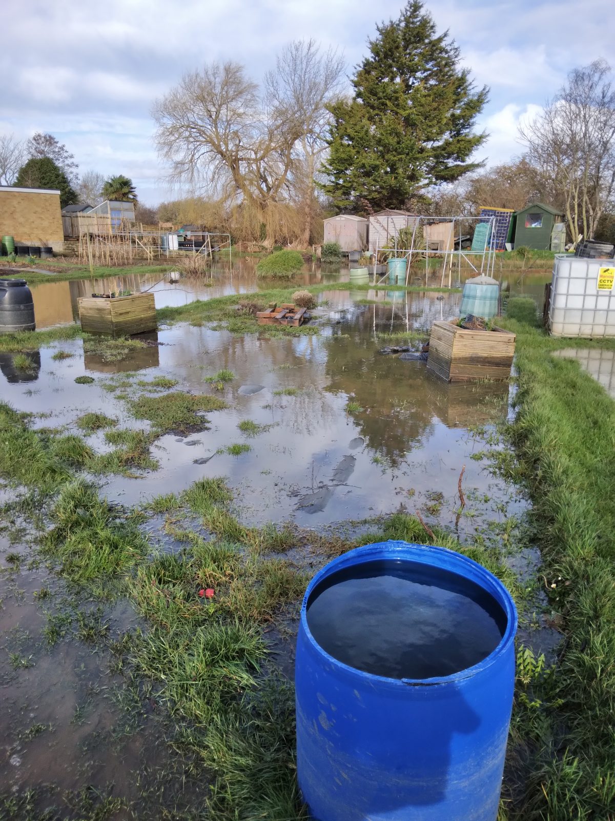
To explore this phenomenon further, following on from my previous investigation on climate change impacts on local food growing, in collaboration with the Eastbourne Food Partnership, I paid a visit in June 2024 to some allotments at Pevensey Bay owned by Pevensey Parish Council, situated off Waverley Gardens. These allotments are next to the Salt Haven, one of the main drainage channels running through the village, and therefore had a history of flooding incidents. From my conversations with some of the allotment holders on site, it was clear that many of the allotments there are flooded at least once every year, but that the winter of 2023-24 was the worst in living memory for flooding, as there were about 4 or 5 very severe flooding incidents. Not all the site gets flooded, as about half the allotments are on higher ground as much of the site slopes gently upwards from the Salt Haven. But all those allotments that back directly onto the haven do flood every year.

The main impact of the flooding is that growing vegetables is pretty much impossible in winter on the areas that do flood, but it was noticeable that there were many large, mature fruit trees and bushes on the areas that experienced flooding every year, and that they seemed to be flourishing, with plenty of fruit developing on them, which seemed to indicate a high degree of tolerance to the flooding than if vegetables were planted, perhaps indicating how the allotment holders had adapted to such flooding by earmarking those areas just for fruit growing. Certainly the allotment holders I spoke to were phlegmatic about the flooding situation, accepted that only fruit trees were capable of surviving the flooding and just planned most of their vegetable growing higher up on the slope above the flooding level. But they reported that because there had been so much rain over the previous winter, the whole site was so waterlogged that most vegetable planting had to be significantly delayed until May, shortening the growing season quite considerably. The difficulties for growers on the site is reflected in the fact that the rental charges for the allotments are much lower than on other allotments in the area, especially in Eastbourne. However, it was clear from my site visit that, once planting had finally got under way, the productivity of the site appeared to be high, with most allotment plots demonstrating a healthy abundance and growth of crops.

One allotment holder was keen to show me a drainage pipe outlet that was below the haven bank as it apparently aids the flooding of the site by allowing the water to flow easily onto the site well before the haven breaks it banks, leading to a much more rapid and more frequent flooding of the site than perhaps should be the case. It appears that there is no tide flap (or the tide flap is damaged or malfunctioning) on the haven side of the pipe to shut off the flow when the water level in the haven rises above the level of the pipe. I heard that there are probably several other similar pipes on site within the bank undergrowth with the same or similar issues, which has been raised by some allotment holders with the local Environment Agency staff to no avail apparently.
It does raise the possibility of whether a survey could be done at some point (perhaps by the Blue Heart Project or an organisation funded by it?) to investigate what kind of pipe drainage does actually exist along the Salt Haven and how it affects water levels both within the haven and beyond its banks. Such a survey would presumably involve extensive clearing of the undergrowth along the bank to check where the pipes are and what condition they are in. But it would perhaps generate valuable data about how the haven actually functions in a critical stretch of it before it reaches the sea, and also create more accurate data about how fluvial flooding impacts Pevensey Bay generally, as many of the gardens elsewhere in the village also experience flooding from the drainage channels.
One of the ways in which we can tackle the climate crisis is through tree planting. However, this may not be as simple as it seems, it is certainly not a quick solution, and it is definitely not a substitute for reducing CO2 and other greenhouse gas emissions.
Why are trees and woodlands so important in tackling the climate crisis? Because they store carbon within their structures, or biomass as it is technically referred to. However, it is worth pointing out that equal or even greater amounts of carbon are stored in woodland soils, so it is not just the tree it is what is below the tree that is also important. while woodland soils store substantial amounts of carbon, many grassland soils, particularly those of wet grasslands, and other wetland habitats store vastly more carbon than woodland soils1. Which is good to know, because although Eastbourne does not have a lot of tree cover, especially as woodland, it has large areas of wet grassland in the form of grazing marsh in the Eastbourne Park and Eastbourne levels areas.
East Sussex is one of the most wooded counties in England, with 17% woodland cover compared to the national average of 12.5%. But if you live in Eastbourne, that might seem a stretch to imagine given that Eastbourne and much of the surrounding landscape are not very wooded. That is because the bulk of woodland in the county is within the High Weald, north of Horam, which is in fact the most woodland landscape in the whole of England.
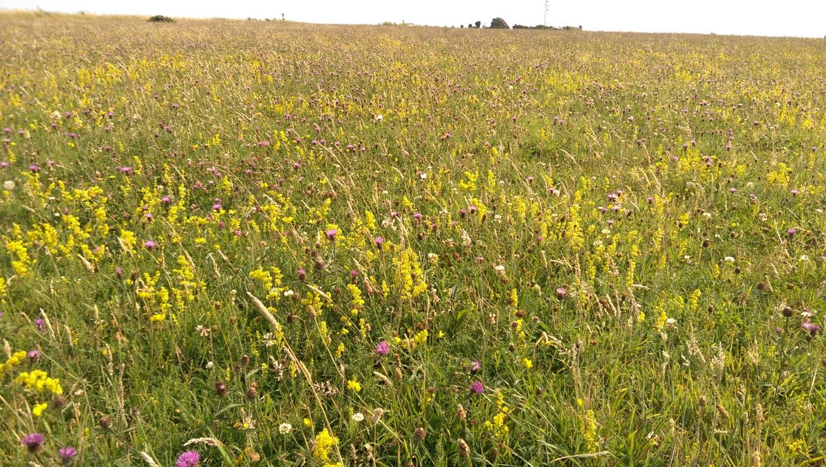
So, does this mean lots of tree planting should be happening in and around Eastbourne? Well, this is actually quite a complex question. Eastbourne has a completely different underlying geology to the High Weald, which has led to a different historical land use, and that in turn has led to the development of very different, but no less important habitats, which is why the landscape around Eastbourne and the Downs at this Eastern end are characteristically different from the low and high Weald of Sussex. Take the chalk grassland on Eastbourne’s doorstep on the Downs. This is an internationally rare habitat, with 80% of the original extent of chalk grassland lost since WWII. Much of the loss in the last 80 years has been to arable conversion on the dip slopes and spreading secondary woodland on the scarp slopes. Secondary woodland is tree and shrub cover that has naturally regenerated because of extensification – the opposite of agricultural intensification – the land is no longer actively managed.
The South Downs National Park Authority in conjunction with Sussex Nature Partnership have produced an ArcGIS map which helps to sense check potential sites across both East and West Sussex, and the full extent of the South Downs National Park for woodland creation. This map draws on national and local data and is the best woodland opportunity mapping tool we have because it has been developed specifically to be used locally. It removes areas not suitable for woodland creation that are often other important habitats, it then weighs both positive and negative factors of the remaining areas across the counties to give one of three scores depending on how sensitive (suitable) the area is for tree planting. The one down side to this excellent tool is that is cannot be used to ascertain suitability for urban tree planting, as urban areas are screened out.
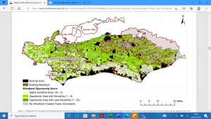
Image source: Mapping Woodland Opportunity in Sussex and the South Downs National Park Technical report, 2022
The map can be found by clicking on the link below. There is a storymap element which explains how the maps work, but if you scroll to the bottom there is an interactive map, which is zoomable:
Sussex and South Downs Woodland Opportunity Mapping (arcgis.com)
This mapping work suggests there is not a great deal of opportunity for woodland creation around Eastbourne. But that is OK, because Eastbourne has other naturally occurring habitats that are just as important if not more important in the fight against climate change. And anyway, the rest of Sussex, and in particular the High Weald AONB holds a place for us with its woodland cover, the same way that the Downs holds chalk grassland for the rest of Sussex. It is a reminder that looking after and restoring all habitats for biodiversity and for us is important, including for future generations, regardless of where those habitats are found.
1 R Gregg, J. L. Elias, I Alonso, I.E. Crosher and P Muto and M.D. Morecroft (2021) Carbon storage and sequestration by habitat: a review of the evidence (second edition) Natural England Research Report NERR094. Natural England, York

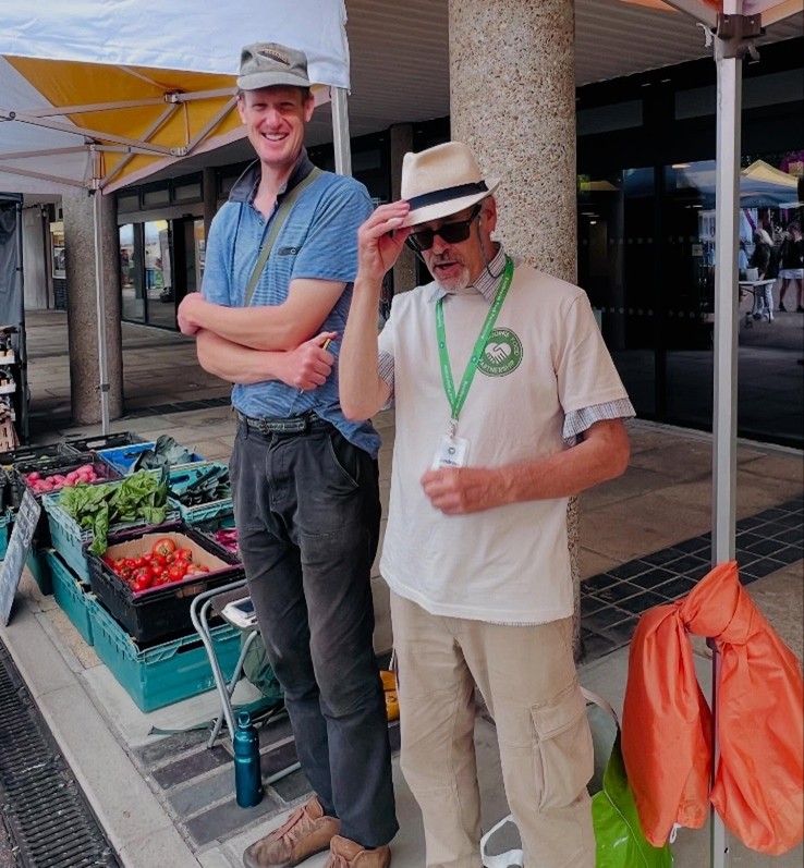
March 15th was a significant day in the Eastbourne Carbon Neutral 2030 (ECN2030) campaign, as it was the first chance for over two years for the many groups and organisations within the campaign to get together again in person to share their progress and their challenges since the campaign was launched back in January 2020. The gathering was co-sponsored by Energise Sussex Coast and the Warm This Winter coalition. The venue, Eastbourne Town Hall, was offered free of charge by Eastbourne Borough Council, together with substantial logistical support from the town hall staff, who did so much to ensure that the event was a success.
The gathering featured updates from many of the campaign’s members, some of them including slideshow presentations. First up was Andrew Durling, Executive Director of the Eastbourne Eco Action Network CIC (EEAN CIC), which organised the gathering. He delivered a welcome speech that set the context for the campaign, explained what its 2030 target meant in terms of actual carbon emissions reduction, and reported on some of the recent activities of the EEAN CIC which have facilitated the campaign. He also briefly introduced the One Planet Eastbourne platform that is being developed to help map the entire ECN2030 campaign in a visual, interactive way that incorporates as much monitoring data as possible to track progress of the campaign.
Many updates were given by most of the key initiatives within the ECN2030 campaign, and some of them included extensive and well-prepared slideshow presentations. These slideshows can be seen by clicking on these links below:
Other groups that gave updates were: EcoEd2030, Plastic Free Eastbourne, Eastbourne Jubilee Green Canopy, and Wild Bourne.
Here is a screenshot from Energise Sussex Coast’s presentation, which featured a briefing about the Energy Champions scheme that will be rolled out across Eastbourne during 2023 with the assistance of the EEAN CIC: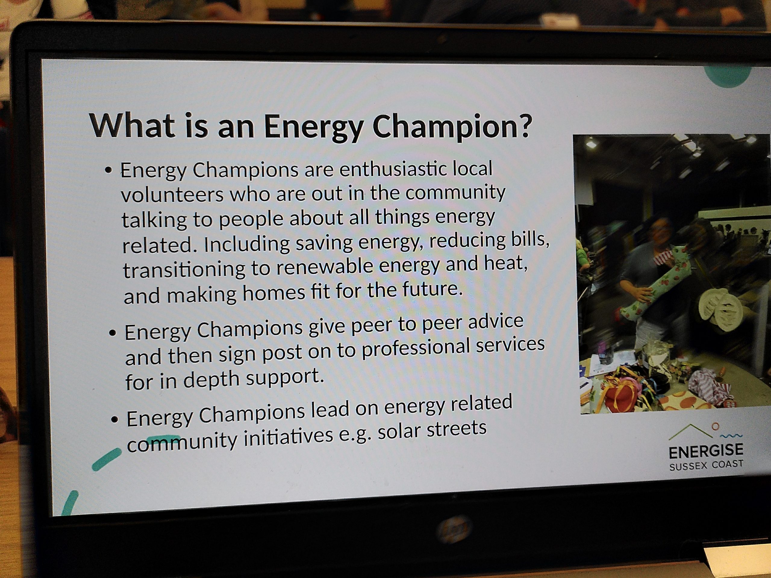
If you wish to train to become an Energy Champion, please contact kate@energisesussexcoast.co.uk or andy@ecoactioneb.co.uk
The updates given clearly illustrated the depth and breadth of the ECN2030 campaign and the large number of local volunteers giving so much of their time and energy to taking real action to ensure that the campaign make real progress whilst simultaneously improving the quality of life, and the health of the local environment, within the town at the same time.
The EEAN CIC intends to organise further ECN2030 Gatherings at regular intervals, hopefully every three months, in order to keep the momentum going for networking within the ECN2030 campaign and to showcase even more of the projects and initiatives within the campaign. Making Eastbourne a town that does its fair share of reducing its carbon emissions as well as learning to live within the ecological boundaries of our one and only livable planet is an ambitious and worthy goal that requires the whole of our community to come together and collaborate to achieve it. The ECN2030 Gathering on March 15th will hopefully be seen as an important step in facilitating that collaboration.
Eastbourne is known as seaside town, and the eastern entry point to the South Downs National Park. On one side Eastbourne has the chalk grasslands of the Downs, one of the most species diverse habitats in England. And, on the other side, the wetlands of the Eastbourne and Pevensey levels. Wetlands being globally the most valuable habitats for the services they provide to us – known as ecosystem services.
There is probably far more variety of wildlife habitats than you realised in and around Eastbourne, including: good quality semi-improved grassland, chalk grassland, lowland meadows, lowland heathland, coastal and floodplain grassland, traditional orchards, ancient semi-natural woodland, lowland fens, reedbeds, deciduous woodland, and marine cliffs and slopes. Many important habitats are already mapped, especially those referred to as ‘priority’ habitats. These are considered to be the most threatened habitats, and often requiring appropriate management to restore and enhance them. An easy way to get to grips with the types of habitats in and surrounding Eastbourne, is to look on at the publicly available habitat mapping data provided by Defra (department for environment, food and rural affairs) MAGIC (defra.gov.uk) As an ecologist, the first thing I always do when asked about a particular site is to check these maps and find out, which if any priority habitats are at a particular site.
The map below shows many, but not all, of the priority habitats in and around Eastbourne. Each colour is a different habitat type. For example, the blue is grazing marsh – and that is why it is found around the wetlands of Eastbourne levels and Cuckmere Haven area. The Khaki colour is chalk (calcareous) grassland, naturally this is found on the chalk downland to the west of Eastbourne.
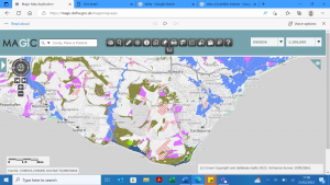
It is worth noting that, there are many important sites that are not on ‘priority’ habitat maps, therefore it is best to treat this data as indicative only, but it certainly gives a good overview. The map also does not indicate the condition of the habitat. Some sites may be thriving habitats, whilst other sites may be in desperate need of appropriate management to restore them back to a good condition.
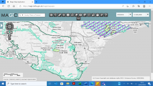
Priority habitats are different however from statutory protection. There can often be some overlap, but many many priority habitat sites have no legal protection. In and around Eastbourne, there are a couple of national nature reserves – Lullington heath, and the Pevensey levels, and a number of Sites of Special Scientific Interest (SSSI) surrounding Eastbourne. SSSI sites have the highest level of national protection, and generally best represent our national heritage either in flora and fauna or geology. This includes the chalk grassland at Willingdon Down found on the Downs behind Willingdon village, and the chalk cliffs which start at the Meads end of the town. Some of the SSSIs are in good condition, whilst others are sadly in a declining in condition, and need urgent appropriate management to help restore them back to the highly valuable habitat they are. This unfortunately includes much of the chalk grassland on the Downs directly above Meads. Whilst the Pevensey levels are generally regarded to be recovering back to good condition.
Statutory sites are also mapped and publicly available from Defra Magic Map Application (defra.gov.uk), and the maps can be used very quickly to assess whether a site has any protection and often what condition the site it is in. The map below shows a variety of conservation designations, from the turquoise stripes of SSSI sites, to the lime green national nature reserves. Of course, every site that should be protected isn’t, and if you compare this map to the one above, you will immediately see quite the discrepancy in priority habitat sites and actual protected sites. But this does not mean these sites are any less valuable for the wildlife that lives there.
If you have the time, I encourage anyone interested to take a look at these maps if not already familiar with them. They are a great resource that are used by professional ecologists and conservationists all the time, and luckily happen to be available to all.