
This blog post is by Sarah Brotherton, a member of Wild Bourne, a new nature conservation group within the Eastbourne Eco Action Network:
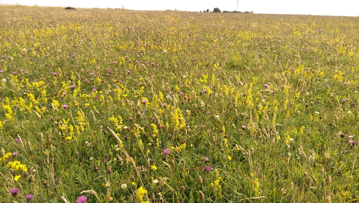
Eastbourne is known as seaside town, and the eastern entry point to the South Downs National Park. On one side Eastbourne has the chalk grasslands of the Downs, one of the most species diverse habitats in England. And, on the other side, the wetlands of the Eastbourne and Pevensey levels. Wetlands being globally the most valuable habitats for the services they provide to us – known as ecosystem services.
There is probably far more variety of wildlife habitats than you realised in and around Eastbourne, including: good quality semi-improved grassland, chalk grassland, lowland meadows, lowland heathland, coastal and floodplain grassland, traditional orchards, ancient semi-natural woodland, lowland fens, reedbeds, deciduous woodland, and marine cliffs and slopes. Many important habitats are already mapped, especially those referred to as ‘priority’ habitats. These are considered to be the most threatened habitats, and often requiring appropriate management to restore and enhance them. An easy way to get to grips with the types of habitats in and surrounding Eastbourne, is to look on at the publicly available habitat mapping data provided by Defra (department for environment, food and rural affairs) MAGIC (defra.gov.uk) As an ecologist, the first thing I always do when asked about a particular site is to check these maps and find out, which if any priority habitats are at a particular site.
The map below shows many, but not all, of the priority habitats in and around Eastbourne. Each colour is a different habitat type. For example, the blue is grazing marsh – and that is why it is found around the wetlands of Eastbourne levels and Cuckmere Haven area. The Khaki colour is chalk (calcareous) grassland, naturally this is found on the chalk downland to the west of Eastbourne.
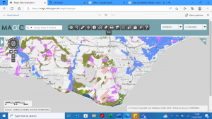
It is worth noting that, there are many important sites that are not on ‘priority’ habitat maps, therefore it is best to treat this data as indicative only, but it certainly gives a good overview. The map also does not indicate the condition of the habitat. Some sites may be thriving habitats, whilst other sites may be in desperate need of appropriate management to restore them back to a good condition.
Priority habitats are different however from statutory protection. There can often be some overlap, but many many priority habitat sites have no legal protection. In and around Eastbourne, there are a couple of national nature reserves – Lullington heath, and the Pevensey levels, and a number of Sites of Special Scientific Interest (SSSI) surrounding Eastbourne. SSSI sites have the highest level of national protection, and generally best represent our national heritage either in flora and fauna or geology. This includes the chalk grassland at Willingdon Down found on the Downs behind Willingdon village, and the chalk cliffs which start at the Meads end of the town. Some of the SSSIs are in good condition, whilst others are sadly in a declining in condition, and need urgent appropriate management to help restore them back to the highly valuable habitat they are. This unfortunately includes much of the chalk grassland on the Downs directly above Meads. Whilst the Pevensey levels are generally regarded to be recovering back to good condition.
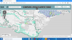
Statutory sites are also mapped and publicly available from Defra Magic Map Application (defra.gov.uk), and the maps can be used very quickly to assess whether a site has any protection and often what condition the site it is in. The map below shows a variety of conservation designations, from the turquoise stripes of SSSI sites, to the lime green national nature reserves. Of course, every site that should be protected isn’t, and if you compare this map to the one above, you will immediately see quite the discrepancy in priority habitat sites and actual protected sites. But this does not mean these sites are any less valuable for the wildlife that lives there.
If you have the time, I encourage anyone interested to take a look at these maps if not already familiar with them. They are a great resource that are used by professional ecologists and conservationists all the time, and luckily happen to be available to all.